
Page 95 - Calculating Agriculture Cover 20191124 STUDENT - A
P. 95
CH 9] Calculating Agriculture 9-5
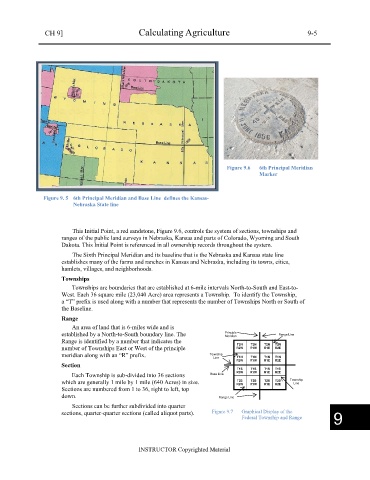
Figure 9.6 6th Principal Meridian
Marker
Figure 9. 5 6th Principal Meridian and Base Line defines the Kansas-
Nebraska State line
This Initial Point, a red sandstone, Figure 9.6, controls the system of sections, townships and
ranges of the public land surveys in Nebraska, Kansas and parts of Colorado, Wyoming and South
Dakota. This Initial Point is referenced in all ownership records throughout the system.
The Sixth Principal Meridian and its baseline that is the Nebraska and Kansas state line
establishes many of the farms and ranches in Kansas and Nebraska, including its towns, cities,
hamlets, villages, and neighborhoods.
Townships
Townships are boundaries that are established at 6-mile intervals North-to-South and East-to-
West. Each 36 square mile (23,040 Acre) area represents a Township. To identify the Township,
a “T” prefix is used along with a number that represents the number of Townships North or South of
the Baseline.
Range
An area of land that is 6-miles wide and is
established by a North-to-South boundary line. The Principle Range Line
Meridian
Range is identified by a number that indicates the T2N T2N T2N T2N
number of Townships East or West of the principle R2W R1W R1E R2E
meridian along with an “R” prefix. Township
Line T1N T1N T1N T1N
R2W R1W R1E R2E
Section
T1S T1S T1S T1S
Each Township is sub-divided into 36 sections Base Line R2W R1W R1E R2E
T2S
which are generally 1 mile by 1 mile (640 Acres) in size. R2W R1W T2S T2S Township
T2S
Line
R2E
R1E
Sections are numbered from 1 to 36, right to left, top
down. Range Line
Sections can be further subdivided into quarter
sections, quarter-quarter sections (called aliquot parts). Figure 9.7 Graphical Display of the
Federal Township and Range
9
INSTRUCTOR Copyrighted Material