
Page 92 - Calculating Agriculture Cover 20191124 STUDENT - A
P. 92
9-2 Land, Soils and Fertilizers CH 9]
measurements for volumes, areas and weights. The metric system is based on the decimal system
beginning with millimeters, and using variations of powers of 10 to include centimeters, meters,
kilometers, and various other measurements for volumes, areas and weights. You will recognize that
in the English system of measurement 12
inches equals 1 foot and 3 feet equals 1
yard; and for the metric system 1 meter is
equivalent to 39.37 inches, though it takes
1,000 millimeter to equal 1 meter, or 100
centimeters to equal 1 meter and 1000
meters to equal 1 kilometer.
Land areas in the United States are
based on the English system.
You want to buy land or sell land, the
land must be described. To own land in any
State of the Union requires a legal
description of the property and there exist
two systems used in the United States. The
first system used is called “Metes and
Bounds” and was the one used when
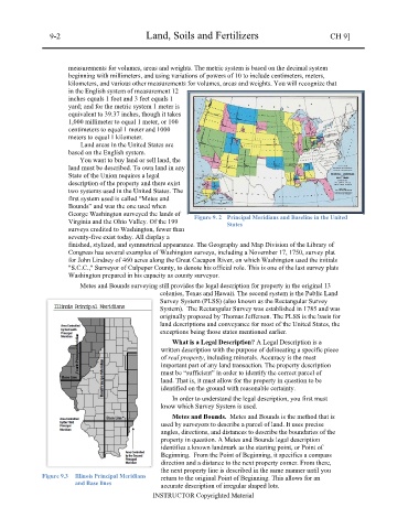
George Washington surveyed the lands of Figure 9. 2 Principal Meridians and Baseline in the United
Virginia and the Ohio Valley. Of the 199 States
surveys credited to Washington, fewer than
seventy-five exist today. All display a
finished, stylized, and symmetrical appearance. The Geography and Map Division of the Library of
Congress has several examples of Washington surveys, including a November 17, 1750, survey plat
for John Lindsey of 460 acres along the Great Cacapon River, on which Washington used the initials
"S.C.C.," Surveyor of Culpeper County, to denote his official role. This is one of the last survey plats
Washington prepared in his capacity as county surveyor.
Metes and Bounds surveying still provides the legal description for property in the original 13
colonies, Texas and Hawaii. The second system is the Public Land
Survey System (PLSS) (also known as the Rectangular Survey
System). The Rectangular Survey was established in 1785 and was
originally proposed by Thomas Jefferson. The PLSS is the basis for
land descriptions and conveyance for most of the United States, the
exceptions being those states mentioned earlier.
What is a Legal Description? A Legal Description is a
written description with the purpose of delineating a specific piece
of real property, including minerals. Accuracy is the most
important part of any land transaction. The property description
must be “sufficient” in order to identify the correct parcel of
land. That is, it must allow for the property in question to be
identified on the ground with reasonable certainty.
In order to understand the legal description, you first must
know which Survey System is used.
Metes and Bounds. Metes and Bounds is the method that is
used by surveyors to describe a parcel of land. It uses precise
angles, directions, and distances to describe the boundaries of the
property in question. A Metes and Bounds legal description
identifies a known landmark as the starting point, or Point of
Beginning. From the Point of Beginning, it specifies a compass
direction and a distance to the next property corner. From there,
the next property line is described in the same manner until you
Figure 9.3 Illinois Principal Meridians return to the original Point of Beginning. This allows for an
and Base lines accurate description of irregular shaped lots.
INSTRUCTOR Copyrighted Material