
Page 94 - Calculating Agriculture Cover 20191124 STUDENT - A
P. 94
9-4 Land, Soils and Fertilizers CH 9]
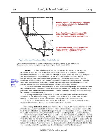
Humboldt Meridian (Top): Adopted 1853. Governing
surveys - California. Initial Point - Latitude 40-25-
02, Longitude 124-07-10
Mount Diablo Meridian (Middle): Adopted 1851.
Governing surveys - California and Nevada.
Initial Point - Latitude 37-52-54, Longitude 121-54
San Bernardino Meridian (Bottom): Adopted 1852.
Governing surveys - California. Initial Point -
Latitude 34-07-13, Longitude 116-55-48
Figure 9.4 Principal Meridians and Base lines in California
California and Nevada image courtesy U.S. Department of the Interior-Bureau of Land Management
Department of the Interior-Geological Survey, Reston Virginia - Public Domain © 1988
California. The three principal meridians in California are the "Mount Diablo" meridian"
established on 1851, the "San Bernardino" meridian established in 1852 and the "Humboldt"
meridian established on 1853. The Latitude and Longitude values shown are North from the equator
and West of Greenwich, England values. The Mt. Diablo meridian controls USPLSS land
descriptions within the central and northern portions of California and all of Nevada. The San
USPLSS: Bernardino meridian controls USPLSS land descriptions within the southern portion of California
United States
Public Land and a small portion of land near Yuma, Arizona. The Humboldt meridian controls USPLSS land
Survey descriptions within a small portion of northern California located along the coast.
System. The San Bernardino meridian, established in 1852, is one of three principal meridians in the state
of California. Because of the state's shape, three meridian–baseline sets are required for surveys in all
parts of the state. The San Bernardino meridian is used for Southern California, and some townships
in Arizona which also references it.
The initial point (datum) is at the summit of Mount San Bernardino, in the San Bernardino
Mountains, in San Bernardino County, California. It is at an elevation of over 10,000 feet (3,000
meters). The meridian runs North–South from the initial point 34°07′13″N 116°55′48″W.
The city of San Bernardino has main streets that are Baseline and Meridian, and each of these
streets are actually on the Base line and Meridian in Southern California.
Sixth Principal Meridian. The Kansas-Nebraska Act of May 30, 1854 created the territories of
Nebraska and Kansas, which had to be surveyed before settlement of the prairies could proceed. The
Sixth Principal Meridian, like the Fifth Principal Meridian a few hundred miles east, is a north/south
line used to survey several states, within an area mostly acquired as part of the Louisiana Purchase.
Surveyors started where the 40th degree of latitude met the Missouri River, and headed west to
establish the baseline. On May 8, 1855 Charles A. Manners set a cast iron monument on the bluff
o
west of the Missouri River at 40 north latitude. After 108 miles they stopped, as instructed by the
Commissioner of the General Land Office, due to “apprehensions of hostile interruptions from the
Indians.” So the Initial Point was set there, and the meridian established north and south. The baseline
was eventually extended west, and became the state line between Nebraska and Kansas.
INSTRUCTOR Copyrighted Material